

Sirwan Regional Project
, a multi-period mound, in the foreground (©Sirwan Regional Project)")
The Sirwan Regional Project (SRP) explores the archaeological landscapes in and around the river known in Kurdish as the Sirwan and in Arabic as the Diyala in the Kurdish Region of Iraq. Flowing from its headwaters in the mountains of western Iran to its ultimate confluence with the Tigris river just south of Baghdad, the Sirwan/Diyala is a key corridor connecting the Zagros highlands and the lowland plains of Mesopotamia. The SRP is dedicated to uncovering the rich but still poorly known archaeological heritage of this region. The project is directed by Claudia Glatz and carried out in close collaboration with the Garmian Directorate of Antiquities and the Garmian Civilizations Museum.
Project Objectives and Methods
The SRP has been exploring the archaeological landscapes of the Sirwan valley (c. 4000 km2) in the Kurdish region of north-east Iraq since 2013. Prior to the start of the SRP this region was an archaeological terra incognita, with only a handful of the largest sites noted in the Iraqi national atlas of archaeological sites.
The study area is located in the upper reaches of a drainage basin that forms one of the main tributaries of the Tigris river. It was historically, and remains today, the primary route connecting the plains of central Mesopotamia with the rugged uplands of the Zagros mountains in western Iran, intersecting several branches of the Silk Routes. As such, the region constituted a zone of documented historical importance to lowland colonists and imperial powers and was the focal point of frequent encounters between highland and lowland communities.

Our understanding of these highland-lowland relationships and their role in key socio-cultural developments, including the emergence of the world’s first urban and later imperial powers in Mesopotamia and Iran, however, remain little understood, especially from a bottom-up, archaeological point of view.
SRP’s central research aims are, thus, to investigate the historical and cultural tensions and mixed political and cultural milieus that developed and transformed over the long term as a result of the region’s geographical situation and character.
SRP takes an integrated and multi-scalar approach that includes the exploration of large-scale and long-term trends in the form of regional settlement practices and cultural affiliations through regional survey, targeted geophysical prospections, and test soundings at suitable survey sites. Detailed chronological and cultural resolution is gained through two large-scale excavations at the sites of Shakhi Kora and Kani Masi, which span key phases of Mesopotamian colonial and imperial presence and interaction in the region during the 4th and the 2nd millennia BCE.
Preliminary Results
Regional Survey and Test Excavations
A preliminary satellite-based remote sensing exercise at the start of the project identified over 500 likely archaeological features in the region. So far, SRP has fully document 221 archaeological sites on the ground. The sites recorded thus far include settlement mounds, such as Tepe Imam Mohammed, which you can see in the video below, ruin fields and associated field-systems, caves, water management features, and sites of a ritual or symbolic nature, such as shrines and monuments carved into the living rock. Recorded sites range in date from early prehistory to the early modern period.
The project also carries out geophysical surveys and test excavations at survey sites in order to improve the chronological resolution of the SRP survey record through the dating of stratified samples.
This approach also allows us to identify previously undocumented local cultural traditions and place them in a wider chronological framework.
")
Shakhi Kora Excavations
Shakhi Kora (SRP191) is a c. 6 ha large site that spans from the early to the late 4th millennium BCE (Uruk Period). It is located on the west bank of the Sirwan to the south of the modern town of Kalar. The site provides a unique opportunity to explore the development of the world’s first urban and colonial societies over the longer-term and in the context of highland-lowland relationships. Several consecutive phases of large-scale cooking and consumption installations at Shakhi Kora permit the investigation of the role of centralised food-distribution. The site’s mixed local, Mesopotamian and highland cultural repertoire and their shifting emphases over time allow the detailed study of the social and cultural dimensions of Mesopotamia’s first colonial encounters.
")
To date, SRP has carried out a preliminary magnetic gradiometer survey on the top of the mound, which detected a series of buried structures, one of which appears to be a monumental building. In 2018, we placed a test sounding along the edge of the mound, where the movement of the Sirwan river has eroded a steep cut. In April and May 2019, a first season of large-scale exposures revealed a sequence of large-scale food processing and storage contexts. Four more seasons of excavations are currently planned at Shakhi Kora.
")
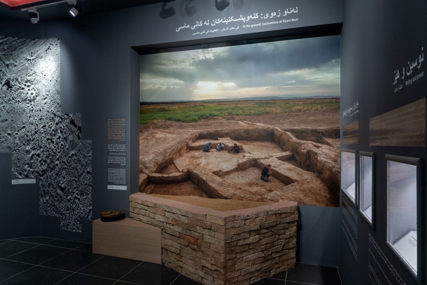
Kani Masi Excavations
The site cluster we refer to as Kani Masi consists of several adjacent low mounds. Since 2016, excavations have exposed a late third to early second millennium BCE (Isin-Larsa to Old Babylonian Period) domestic complex (SRP094) and an associated burial ground (SRP189). Both show interesting cultural links to Mesopotamia and the Zagros region.

SRP046 presents an expansive (c. 60ha) settlement dating to the second half of the second millennium BCE (Middle Babylonian or Kassite Period). Here, we have exposed a monumental complex, closely associated with central Mesopotamia in cultural terms. Also recovered was evidence for large-scale communal feasting, with organic residue analyses confirming that a variety of flavoured barley beers were consumed.
, September 2017 (©Sirwan Regional Project)")
Several clay sealings confirm a close administrative connection between Kani Masi and the Kassite political sphere. A large-scale cooking area, as well as ceramic and metal production facilities serviced the monumental complex. The post-occupation phase of the monumental complex also yielded evidence for hitherto undocumented ritual practices associated with the closure and commemoration of buildings and activity areas.
")
Cultural Heritage
, August 2018 (©Sirwan Regional Project)")
Between 2018 and 2020, a collaborative project between the University of Glasgow, the Antiquities Directorates and Museums of Sulaymaniyah and Garmian as well as the UK-based heritage organisation Inherit, carried out a number of projects to promote and protect the region’s rich archaeological heritage.
Archaeological Practice and Heritage Protection in the Kurdistan Region of Iraq delivered practical field-based training during SRP field-seasons, 4-day training workshops on archaeological interpretation and archaeology’s political dimensions, as well as training for local antiquities officials in remote and on-the-ground site condition monitoring and methods for community engagement.
Subsequent work carried out by Nawzad Latif, Amanj Amin, Mohammed Ali and Sarwat Sarkawt have resulted in a first empirical record of archaeological site condition in the Garmian region and in c. 50 rural communities in Sulaymaniyah and Garmian engaging in discussions about their archaeological heritage.
")
The project also created two new, and for the region unique, permanent new museum spaces in Slemani Museum and the Garmian Civilizations Museum in Kalar.
")
The new Slemani Museum Kids space is dedicated to providing young visitors with a fun and activity-laden environment, where children, their parents, and teachers can experience, imagine, and creatively express their engagement with the past, expanding as well as complementing the school curriculum.
A second museum space in the city of Kalar focuses on the practice of archaeology and takes the ongoing research of the SRP as its central theme. The permanent, trilingual exhibition demonstrates the immense richness and importance of the information that the mostly unexplored archaeological sites in the region hold. It takes visitors on a journey of how archaeologists explore these landscapes, how they make sense of the information they collect during survey and excavation, and why it is important to protect archaeological sites from damage and destruction.
")
The exhibition helps visitors understand how plausible archaeological stories are constructed, and that their vital ingredient – the ‘archaeological context’, the associations between excavated artefacts and their finds contexts – is lost forever when archaeological sites are looted or damaged by war or industrial development.
The project also produced three themed, trilingual museum engagement boxes, which schools can borrow from the two museums. The boxes contain illustrated information booklets, replica artefacts, and games.
")
For more information on this project and open access teaching resources (videos and booklets), click here.
Publications and Financial Support
Preliminary Publications
- Glatz, C. et al. 2019. Babylonian encounters in the Upper Diyala River valley: Contextualizing the results of regional survey and the 2016-2017 excavations at Kani Masi. American Journal of Archaeology 3: 439-471.
- Perruchini, E., Glatz, C., Hald, M.M., Casana, J. and Toney, J.L. 2018. Revealing invisible brews: A new approach to the chemical identification of ancient beer. Journal of Archaeological Science 100: 176-190.
- Casana, J. and Glatz, C. 2017. The land behind the land behind Baghdad: Archaeological landscapes of the Upper Diyala (Sirwan) River Valley. Iraq 79: 47-69.
- Glatz, C. and Casana, J. 2016. Of highland-lowland borderlands: Local societies and foreign power in the Zagros-Mesopotamian interface. Journal of Anthropological Archaeology 44: 127-147.
- Glatz, C. 2014. Monuments and landscape - exploring issues of place, distance and scale in early political contest. In J. Osborne (ed.). Approaching Monumentality in the Archaeological Record. Buffalo: SUNY Press: 109-134.
Final Report
The SRP team is currently working on the project’s first monograph, with the working title Place, Encounter, and the Making of Borderland Communities in the Zagros-Mesopotamian Interface from c. 5000 to 550 BCE: Results of the Sirwan Regional Project (2013-2020). This first SRP volume will track the region’s early settlement and cultural developments, and examine, over the long term, questions of culture contact, the development and nature of local social complexity, as well as the region’s changing relationships with colonists and early imperial powers in lowland Mesopotamia and highland Iran.
Financial Support
The Gerda Henkel Stiftung, The Alexander von Humboldt Foundation, The British Academy, The British Council-Cultural Protection Fund in collaboration with the Department of Digital, Culture, Media and Sport, The British Institute for the Study of Iraq, The G.A. Wainwright Fund, The Leverhulme Trust, The Carnegie Trust for Universities of Scotland, The Robertson Bequest, The National Science Foundation.
Project Team
")
Project Team
- Claudia Glatz, University of Glasgow - Director
- Salah Mohammed Sameen, Deputy Director of the Garmian Department of Antiquities
- Daniel Calderbank, University of Glasgow – Associate Director
- Francesca Chelazzi, University of Glasgow - Associate Director
- Robin Bendrey, University of Edinburgh - zooarchaeology
- Mette Marie Hald, National Museum of Denmark - paleoethnobotany
- Jakob Lauinger, Johns Hopkins – Assyriology
- Adam Miglio, Wheaton College – Assyriology
- Jessica Pearson, University of Liverpool – bioarchaeology
- Andrea Squitieri, LMU – ground stones
- Emma Baysal, Thrakia University – beads
- Neil Erskine, University of Glasgow – excavation, surveying, data management
- Elsa Perruchini, University of Glasgow, Max Planck Institute Jena - organic residue analysis
- Francesco Del Bravo, Freie Universität Berlin – excavation
- Eric Jensen, University of Arkansas - survey, excavation
- Aphrodite Sorotou, Inherit – cultural heritage
- Nawzad Latif, Garmian Department of Antiquities – survey, remote sensing, site monitoring
- Mohammed Ali, Garmian Civilizations Museum – excavation, photography rural community engagement
- Sarwat Sarkawt, Garmian Civilizations Museum – excavation, geophysical survey, rural community engagement
- Awat Baban, Garmian Department of Antiquities – survey, excavation
- Stamos Abatis, Photographer
- Lorraine McEwan, University of Glasgow – illustration
- Aris Palyvos, University of Glasgow – excavation
- Elaine Wilson – administration
- Ahmed Ismail, Garmian Department of Antiquities – excavation
- Imad Ismael, Kifri Department of Antiquities – excavation
- Zhwan Raheem, volunteer – excavation
Past Team Members
- T. Emre Şerifoğlu, Bitlis Eren University, Turkey (Co-Director, 2013)
- Jesse Casana, Dartmouth College, USA (Co-Director, 2013-19)
- Evrim Nazli Şerifoğlu – illustration (2013)
- Autumn Cool, University of Arkansas - geophysical survey (2014)
- Christopher Fletcher, University of Arkansas - geophysical survey (2014)
- Kathleen Nicoll, University of Utah – geomorphology (2014)
- Kathryn Twiss, Stony Brook University – zooarchaeology (2014)
- Mitra Panahipour, University of Arkansas – survey (2014-15)
- Jeff Kerby – photography (2019)
- Elise Jakoby Laugier, Dartmouth College - geophysical survey (2015-2019)